
About Us
About Prakasam
Prakasam District, situated in the heart of Andhra Pradesh’s coastal region, is a land where history, culture, nature, and progress come together to create a unique identity. Named after the legendary freedom fighter and former Chief Minister of Andhra State, Tanguturi Prakasam Pantulu, the district stands as a symbol of courage, heritage, and development. With Ongole as its administrative headquarters, Prakasam has grown into one of the most significant districts in the state, known for its rich traditions, agricultural strength, mineral resources, and scenic beauty.
Spread across vast plains, rolling hills, forests, rivers, and a picturesque coastline along the Bay of Bengal, Prakasam offers a diverse landscape that supports both economic growth and ecological richness. The district is renowned for its world-famous Ongole cattle breed, high-quality granite exports, fertile agricultural lands, and numerous historical and religious landmarks that attract visitors from across the country.
Prakasam’s history is deeply rooted in ancient civilizations and powerful dynasties that once ruled this region. From the Satavahanas and Cholas to the Vijayanagara Empire, each era has left its mark through magnificent temples, inscriptions, and architectural marvels. These historical treasures continue to narrate stories of the district’s glorious past and cultural evolution. Agriculture remains the backbone of the district’s economy, providing livelihood to thousands of families.
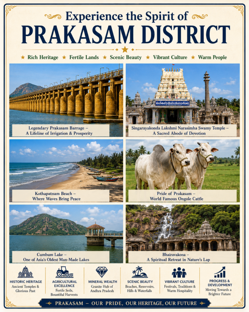
Glance of Prakasam
Area
17,626 km²
Population
3.4 Million+
Language
Telugu
Famous For
Ongole Cattle
Headquarters
Ongole
Coastline
Bay of Bengal
Major Crops
Tobacco & Paddy
Attractions
Bhairavakona
Why Visit Prakasam?
Ongole Cattle Heritage
Discover the world-famous Ongole breed known for strength and global recognition.
Beautiful Beaches
Enjoy the scenic beauty of Kothapatnam and Ramayapatnam beaches.
Sacred Temples
Visit Singarayakonda, Manikeswaram and other spiritual landmarks.
Natural Wonders
Explore Bhairavakona waterfalls and the beauty of Cumbum Lake.
Agricultural Excellence
Fertile lands producing tobacco, paddy, cotton and pulses.
Granite & Mineral Wealth
Home to one of Andhra Pradesh's largest granite industries.
History of Prakasam
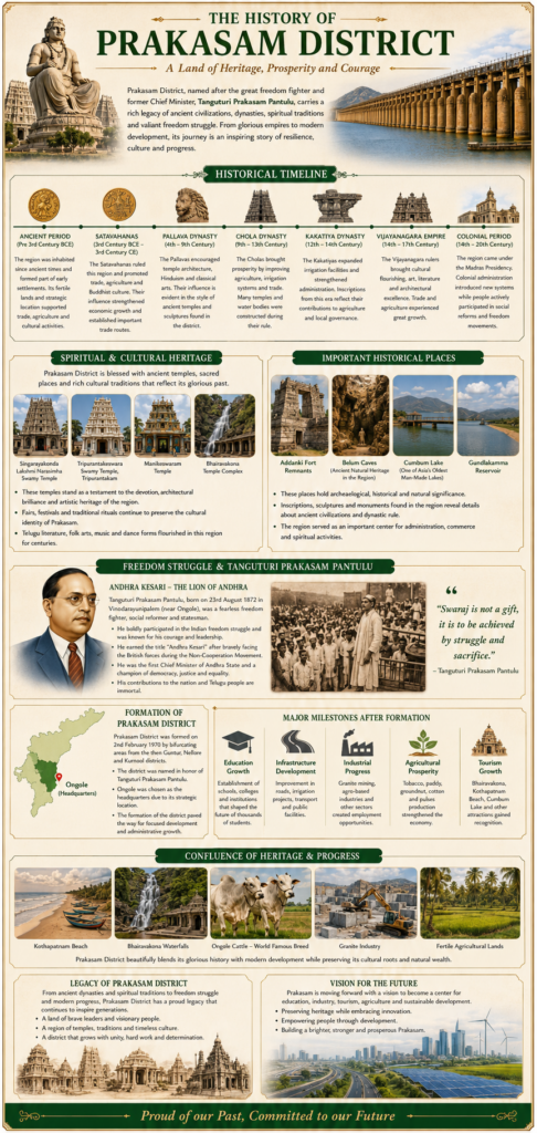
Prakasam District is one of the most historically significant regions of Andhra Pradesh, possessing a rich legacy that spans several centuries. The district reflects the influence of numerous dynasties, kingdoms, freedom fighters, and cultural movements that have shaped its identity over time. From ancient settlements and temple architecture to its role in India’s freedom struggle, Prakasam stands as a proud symbol of heritage, courage, and progress.
Ancient Origins
The history of the region dates back to ancient times when it formed part of several powerful South Indian kingdoms. Archaeological findings, inscriptions, ancient temples, and historical records indicate that the area was inhabited and culturally active for thousands of years. The fertile lands, rivers, and strategic location made the region an important center for trade, agriculture, and religious activities.The district came under the influence of the Satavahanas, one of the earliest major dynasties in South India. The Satavahanas promoted trade, agriculture, and Buddhist culture, leaving a lasting impact on the region’s development. Their rule helped establish important trade routes connecting the Deccan with coastal regions.
Formation of Prakasam District
Prakasam District was officially formed on February 2, 1970, by combining areas from the former districts of Guntur, Nellore, and Kurnool.The newly formed district was named in honor of Tanguturi Prakasam Pantulu to commemorate his outstanding contributions to India’s freedom struggle and public service.Ongole was designated as the district headquarters due to its strategic location and administrative importance.The formation of the district marked a significant milestone in regional development, enabling focused governance, infrastructure growth, and economic progress.
Explore Prakasam Towns
Ongole
| Category | District Headquarters |
| Economy | Trade, Education, Services |
| Major Crops | Tobacco, Paddy, Groundnut |
| Population | Approx. 2.10 Lakhs |
| Approx. Area | 29.6 km² |
| Known For | Ongole Cattle |
| Tourist Places | Kothapatnam Beach, Chennakesava Swamy Temple |
| Special Feature | Administrative & Commercial Hub |
Markapur
| Category | Industrial Town |
| Economy | Slate Industry, Agriculture |
| Major Crops | Cotton, Bengal Gram, Groundnut |
| Population | Approx. 1.00 Lakh |
| Approx. Area | 22.2 km² |
| Known For | Slate Manufacturing |
| Tourist Places | Sri Lakshmi Chennakesava Swamy Temple |
| Special Feature | Slate Capital of Andhra Pradesh |
Chirala
| Category | Coastal Town |
| Economy | Textiles, Fishing, Trade |
| Major Crops | Paddy, Tobacco |
| Population | Approx. 2.00 Lakhs |
| Approx. Area | 28.4 km² |
| Known For | Handloom Sarees |
| Tourist Places | Vodarevu Beach, Ramapuram Beach |
| Special Feature | Textile Hub |
Addanki
| Category | Historic Town |
| Economy | Agriculture, Trade |
| Major Crops | Tobacco, Cotton, Paddy |
| Population | Approx. 45,000 |
| Approx. Area | 23.5 km² |
| Known For | Historic Heritage |
| Tourist Places | Singarakonda Temple |
| Special Feature | Ancient Cultural Centre |
Kandukur
| Category | Agricultural Town |
| Economy | Agriculture, Retail |
| Major Crops | Tobacco, Paddy, Groundnut |
| Population | Approx. 58,000 |
| Approx. Area | 19.5 km² |
| Known For | Tobacco Market |
| Tourist Places | Local Temples |
| Special Feature | Agricultural Market Hub |
Giddalur
| Category | Hill Region Town |
| Economy | Agriculture, Forestry |
| Major Crops | Groundnut, Pulses |
| Population | Approx. 38,000 |
| Approx. Area | 18.3 km² |
| Known For | Nallamala Hills |
| Tourist Places | Gundla Brahmeswaram Wildlife Sanctuary |
| Special Feature | Gateway to Nallamala |
Kanigiri
| Category | Rural Town |
| Economy | Agriculture, Granite |
| Major Crops | Groundnut, Millets |
| Population | Approx. 42,000 |
| Approx. Area | 21.6 km² |
| Known For | Granite Resources |
| Tourist Places | Kanigiri Reservoir |
| Special Feature | Mining & Farming |
Podili
| Category | Agricultural Town |
| Economy | Agriculture, Local Trade |
| Major Crops | Groundnut, Cotton |
| Population | Approx. 33,000 |
| Approx. Area | 16.8 km² |
| Known For | Farming |
| Tourist Places | Regional Temples |
| Special Feature | Fertile Farming Region |
Darsi
| Category | Commercial Town |
| Economy | Agriculture, Business |
| Major Crops | Cotton, Tobacco |
| Population | Approx. 40,000 |
| Approx. Area | 20.4 km² |
| Known For | Regional Trade |
| Tourist Places | Local Temples |
| Special Feature | Business Centre |
Kothapatnam
| Category | Coastal Tourism Town |
| Economy | Tourism, Fishing |
| Major Crops | Paddy, Groundnut |
| Population | Approx. 18,000 |
| Approx. Area | 14.2 km² |
| Known For | Kothapatnam Beach |
| Tourist Places | Kothapatnam Beach |
| Special Feature | Beach Destination |
Prakasam District Population Growth
Population Growth (2011–2021)
Prakasam District Statistics
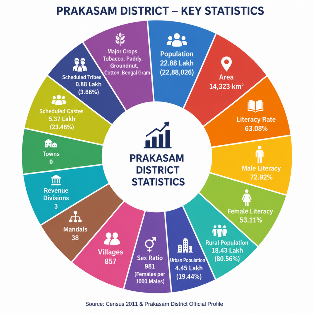
Prakasam District is one of the prominent districts of Andhra Pradesh, distinguished by its vast geographical landscape, agricultural excellence, and rich cultural heritage. Covering an area of approximately 14,323 square kilometers, the district serves as a major center for agriculture, education, commerce, and industry. With a population of over 22.88 lakh, Prakasam reflects a harmonious blend of rural traditions and urban development, making it an important contributor to the state’s economic and social progress.
The district is administratively divided into 3 revenue divisions, 38 mandals, 9 towns, and 857 villages, ensuring effective governance and public service delivery across the region. Agriculture remains the backbone of the local economy, with crops such as tobacco, paddy, groundnut, cotton, and Bengal gram playing a significant role in supporting livelihoods and driving economic growth.
Prakasam District also demonstrates continuous progress in education, infrastructure, healthcare, and industrial development. The district’s literacy rate, expanding transportation network, and increasing investment in public welfare reflect its commitment to sustainable development.
Area Measurement of Prakasam
Prakasam District is one of the geographically largest districts in the state of Andhra Pradesh, covering an extensive area of 17,626 square kilometres. Situated along the southeastern coast of India, the district stretches from the scenic coastline of the Bay of Bengal in the east to the forested Nallamala Hills in the west. This vast geographical expanse provides Prakasam with an exceptional diversity of landscapes, including fertile agricultural plains, rolling hills, rocky plateaus, dense forest areas, mineral-rich terrains, rivers, reservoirs, and a picturesque coastline.The district shares its boundaries with Bapatla District to the northeast, Palnadu District to the north, Nandyal District to the northwest, Sri Potti Sriramulu Nellore District to the south, YSR Kadapa District to the west, and the Bay of Bengal to the east. Its strategic location makes it an important link between the coastal and Rayalaseema regions of Andhra Pradesh, facilitating trade, transportation, and regional development.
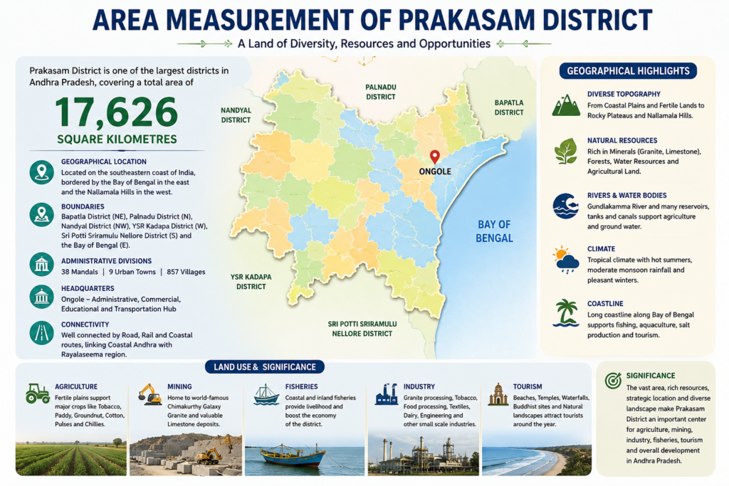
Revenue and Economy of Prakasam District
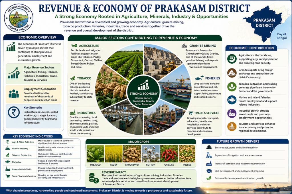
Prakasam District has a diversified economy driven primarily by agriculture, granite mining, tobacco production, fisheries, trade, and small-scale industries. Agriculture remains the backbone of the district, with major crops including tobacco, paddy, cotton, groundnut, chillies, Bengal gram, and pulses. The fertile plains and irrigation facilities support thousands of farming families across the district.The district is internationally renowned for Chimakurthy Galaxy Granite, one of India’s most valuable granite varieties. Granite quarrying, processing, and exports generate substantial government revenue while providing employment to thousands of people. The tobacco industry is another major contributor, with Prakasam being one of Andhra Pradesh’s leading tobacco-producing districts. Fisheries along the Bay of Bengal coastline and inland water bodies further strengthen the local economy through seafood production and exports.